You can communicate with HemisphereGPS receivers and OEM boards.
Program designed for Onboard Instruments.
Geospatial mapping and analysis tool with ESRI file support.
The Survey Import and Export program works with AutoCAD.
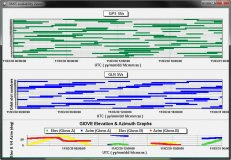
GNSS Satellite Availability Viewer supports mission planning functionality.